My wife got the notion to visit our daughter in Ocean Springs because the weather was going to be nice. She gave me the hint by asking me if the tides were good for fishing the weekend of Saturday April 27. She knows me pretty well. Upon checking I was expecting the tide to be in the typical Spring pattern which is usually high tide during mid-day, but I was interested when I saw the moderate high tide was around 4 PM, which meant moderately skinny water during the sight casting window.


I checked the gauges in Bang’s Lake and the turbidity was a 9NTU. My rule of fives is, “fifty is five inches, five is five feet”, that’s not accurate, but it’s easy to remember and it puts a measurement in perspective for sight casting. A 9 would mean you could see the bottom in 1.5 feet or less of water, and that’s all I care about.
The nice weather held and when I got out on the water the sky was sunny with no haze, the wind was calm and the temperature was cool. The water clarity was holding true to the gauge reading and I was seeing the bottom on my flats or what I call “shelves”, which are red fish hangouts in the shallow areas near the marsh grass.
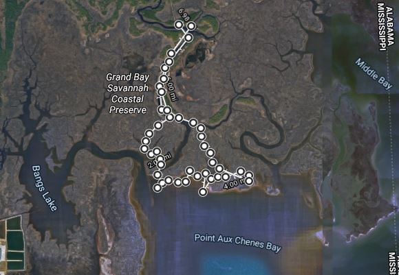
I fished a creek near Bang’s Lake but only saw one red fish. The wind was tolerable so I decided to chance the Point-Aux-Chenes Bay area, which has my favorite spots but it gets too rowdy with a little wind. I decided on what I call the “medium program” which is about a 7 mile round trip. That’s a pretty long trek for my Kajun Kayak, so my trolling motor was appreciated.
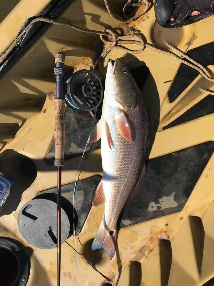
I found the fish below, high and happy, cruising a little shelf off of the first little creek I pushed into. I saw him just twenty feet off the bow, did my little “Samurai” maneuver with the paddle and the rod and cast a Black Charlie about three feet in front of him. I had to pull the fly into his path, but he saw it, swam over, sniffed it like a dog and flared his gills. I love to see those gills flare!
I caught three more good fish in similar situations and I saw about six more of which I got a cast to two but they were spooky and blew off.


The water level was just about right and it made the difference in being able to see the fish when most Spring trips have too much water. The best days, of course, are in the Fall. The water levels were so good that day, when I got back home, I looked up the gauge I was using to find out if I could predict the same type of water levels. I’m calling it, the “Goldilocks zone”, a term used by NASA for planets that might be able to sustain life. Just right, in other words.
The gauge I normally use doesn’t have historical tide level data available by hour so I used the High, Low historical levels for the gauge. With excel formulas I tried to compute the water level at noon (the middle of the sight casting window). Well, due to the complexity of the bell curve, you can approximate it, but things like slack tides, fast tides etc, make it complicated. I spent a lot of time trying to get a formula that was reliable, but the bell curve was throwing me off. I was getting some good calcs, but also some very bad.
So, in desperation, I started looking for nearby gauges that have historical data hoping one might have more data. As luck would have it, I found that the Pascagoula gauge provides historical and future predicted tide levels by date and by hour. That is exactly what I needed and the gauge is very near Point-Aux-Chenes Bay. After comparing the two gauges, I determined the tidal activity at the Pascagoula gauge parallels the PAC area.
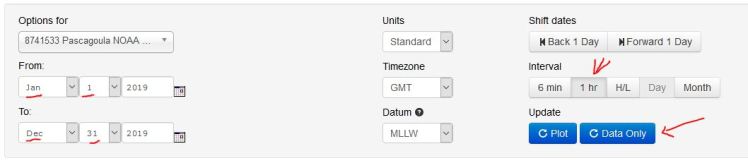
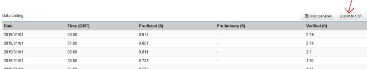
Using the screen above, I ran the extract for the entire year specifying 1 hour intervals and “data only”. I then exported the data as a CSV file.
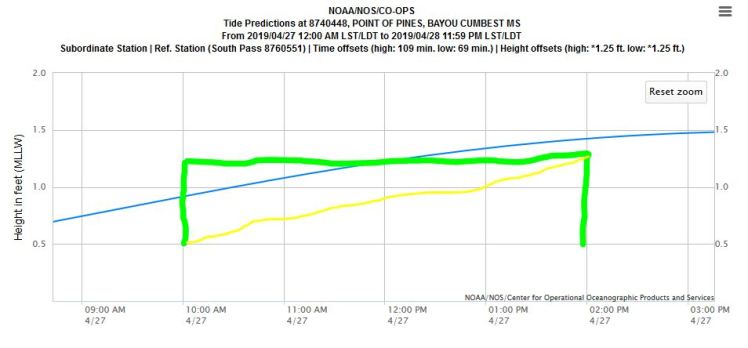
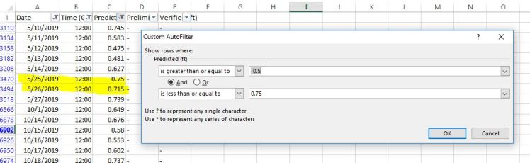
I dropped the exported CSV file into Excel and put a filter on the “predicted” column. The result gave me all of the dates for the year that had a noon tide level of between -.5 and +.75 feet. How did I arrive at using the .75 number? I checked the gauge for the date for 4/27 at noon and the tide level was predicted to be .453 and observed at .81 feet. There was a south wind that day, and south winds push water into the marsh so I assumed that is one reason the gauge read higher. Of course skinny water is what I’m looking for, it’s the high water that sends me back to the ramp. I put a -.5 for the low number and equated the predicted .453 on the Pascagoula gauge to the “Goldilocks” level that I experienced at Point-Aux-Chenes. I bumped it up to .75 to account for the actual/observed reading for that day (.81 in Pascagoula).
I had already done some perusal of tide data looking for a May date to go with some buddies and had already figured out that 5/25 has a late high tide and a moderate tide level so I was really happy to see 5/25 pop out of the spreadsheet with a .75 water level at noon. And if you look below May, the next date is in October, so the 5/25 weekend is about the last date where the water will be that low at noon.
So now I have a spreadsheet I can use to plan fishing trips without having to do the time consuming and eye straining task of looking at the graphs. And it will only take a couple of minutes to do next year’s. High technology for better sight casting!
I want to close on the following note. The Point-Aux-Chenes area is eroding at an alarming rate, at least ten feet per year. Numerous studies have been done and they all say the same thing. I entered project 4248 in the MDEQ RESTORE project portal to potentially attract attention and funding to have some living shoreline or wave attenuation work of some kind to protect the shoreline. I am continuing that fight and and asking the Fly Fishers International and our Gulf Coast Council for funding for a site assessment to determine the best measures that can be applied to mitigate the erosion. I recently bumped into a study that says basically what I have been saying all along but with a number, “Proposed nourishment of the Grande Batture shoals with 6,000,000 cubic yards of dredged material would not only restore the former barrier chain, but would also slow rates of bayshore erosion and marsh deterioration.”
Halleleujah brother, that’s what I’ve been saying all along, only I couldn’t put a number to it. Here is the direct quote from the 1995 study:
Meyer-Arendt, K.J. & Kramer, K.A.. (1991) The remnant shoals of the Grande Batture Islands comprise the seaward margins of a late Pleistocene/Holocene delta lobe of the Pascagoula-Escatawpa fluvial system. Sediment discharge into Mississippi Sound via the Bayou Cumbest distributary initiated phases of aggradation and progradation. As fluvial inputs decreased, wave action and longshore drift processes reworked the deltaic headland and produced the Grande Batture Islands. Historically, these islands sheltered the extensive nutrient-rich intertidal marshes as well as productive oyster beds in Pt. aux Chenes Bay and Grand Bay. An 1853 survey delineated about 450 acres of barrier island complex extending over 5 miles in length, yet by the 1950s it had been reduced to shoals. Shoreline erosion rates have averaged 15ft/yr since 1853, and the remaining headland is presently retreating at even higher rates. Proposed nourishment of the Grande Batture shoals with 6000 000 cubic yards of dredged material would not only restore the former barrier chain, but would also slow rates of bayshore erosion and marsh deterioration. Optimal salinity regimes for oyster production might also be re-established. Preliminary indications are that the costs of island restoration and periodic renourishment would be offset by the benefits derived. -Authors
Of course, other measures are available now and hopefully someone can help us flesh out project 4248 to garner RESTORE money to preserve this incredible place. Stay tuned and we may ask for your support in coming months, hopefully before the RESTORE money runs out.
