I remember an episode of the sit-com “WKRP Cincinnatti” where Les Nesman, the agriculture-focused news anchor was being hit on by some seductress. She said to him in a husky voice, “I like to think that a person’s name says a lot about the type of person he is. What was your name again? ”
“Les”
Sometimes you do want less, sometimes less is more. But when it comes to our marshes, our estuaries, less is not more, less is less. Less fish, less places to fish. Less nature. Less fun. Less everything.
The following video by the USGS is a time-lapse video made at one of my favorite fishing holes in the Grand Bay National Estuarine Research Reserve, Jose Bay. In the video there is a wooden plank structure that I have cast my fly to many times. Who knows, if you slow the video down you may even see one of my spoon flies drop in!
But, it shows something that makes me want to cry out. Please watch the video below:
Link to Grand Bay erosion video by USGS
Kayak fly fishing, something that I enjoy, is not the greatest in Grand Bay, but there is more than just fishing that draws me there. Personally I think the fishing could be much better but that’s a whole different article. For my kind of fishing, Louisiana has much better fishing, in my opinion. But Grand Bay is unique and has much more to offer than just fishing. This is simply about not losing what we have.
Grand Bay is kayak accessible from the mainland. As a Mississippi resident I can I fish there and avoid paying for Louisiana’s out-of-state one day license ($17.50) or the annual  license ($90). Grand Bay is an easier drive than Louisiana, not having to fight heavy traffic through New Orleans is a draw for me. Accommodations nearby are plentiful and affordable. The area is beautiful and I know how to fish it. The wildlife viewing is unsurpassed. I always see bald eagles and ospreys, pelicans, egrets and other shorebirds. The longleaf pines and maritime oaks are beautiful. I sometimes see sharks working like bird dogs in the same grass beds I am fishing. Dolphins often appear ransacking the flats for fish. Sometimes pelagic finfish come near enough to catch. I have caught Spanish mackeral and Jack Crevalle in front of the single plank structure you see in the video.
 And there is a unique Indian history that I haven’t experienced any where else too, highlighted by the shell “middens” which make a good place to pull up a kayak and at the same time demonstrate how the marsh can be preserved as they still serve a purpose, protecting the marsh from wave attack erosion.
I have seen Grand Bay under attack many times. Katrina (2005), the BP oil spill (2010), the phosphate stack spill (2005). It is a resilient place, however one thing it does not recover from is the loss of its marsh sediments and grasses by wave attack. Sediments no longer enter the Grand Bay marsh with any volume, most of that is natural as the Escatawpa changed its course and there hasn’t been any marsh building for some time. Flood control and diversion hasn’t helped that. You can find a great deal of this information in the Grand Bay NERR Site Profile. It is a wealth of information on just about every facet of Grand Bay and it contains information as to the historical extent of the area around where the USGS video was made. It provides a brief description of the history of the area and the subsequent erosion:

Note the mention of a long spit of land extending from the South Rigolets: “The 1853 U.S. Coast Survey Chart shows a 7.8 km long continuous spit (182 ha) extending from marshy South Rigolets Island.” I can tell where the old marsh used to be as I sometimes fish the remnants in my kayak. The old South Rigolets are now just mud bars with the small islet mentioned above.
I was oblivious to such information when I began fishing the area. It was only after I noticed the erosion that I began researching all available information. The thing that alerted me to the erosion by wave action was a favorite little point that I would fish at the mouth of Bayou Cumbest. I would stand on that point and let the running tidal current drift my fly over a drop-off to catch specks, reds, flounder, Spanish, sheepshead and black drum. But every time I went to my point it would be shorter than the previous visit. It was easy to see what was happening as the waves constantly attack the soft banks, washing the mud away from the roots of the grass. It was frustrating and it tore at my heart to watch that point disappear.
In July 2012, Congress passed the (RESTORE Act) in response to the Deepwater Horizon oil spill. The RESTORE Act dedicates 80 percent of all administrative and civil penalties related to the Deepwater Horizon spill to a Gulf Coast Restoration Trust Fund.
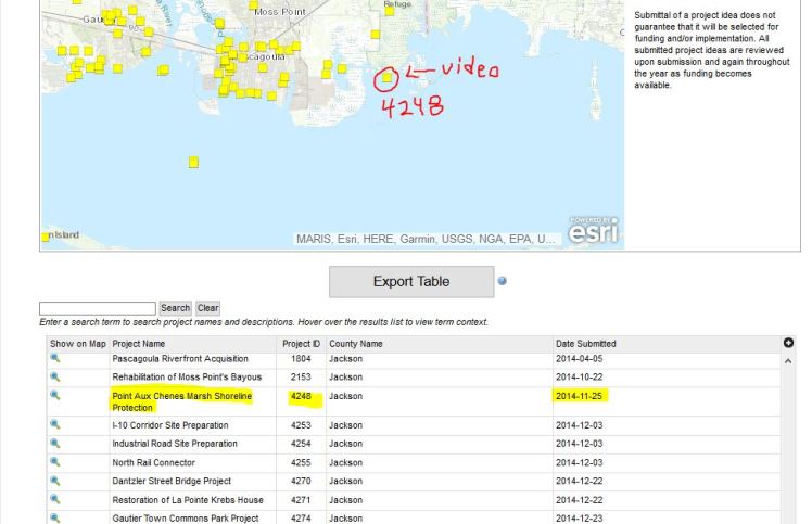
The Mississippi Department of Environmental Quality was tasked with determining how to spend RESTORE money from the BP oil spill. They provided a website where people could enter their ideas or suggested projects to help recover the marsh. In November of 2014 I found this website and entered a project suggesting a breakwater in front of Point Aux Chenes Bay and the Rigolets. Project 4248 is still on the website, see below:
I would like to ask people to sign on to the RESTORE Project Overview page and look at the submitted projects and ask yourself how many of these projects would actually be in the direction of restoring the marsh. Many of them are in fact good projects, but I think far too many are urban, designed to enhance tourism or increase property values with pojects such as promenades, beach improvement, “living shorelines”, ballparks, aquariums, parking lots, fiber optic cable infrastructure, highway interchanges, aircraft hangars and boat launches. The list goes on and on. I’m not saying that some good projects haven’t gotten off the ground. In fact what I have seen and heard about La France marsh protection and Round Island restoration are good. Below are two acquisition projects I like: 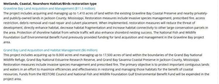
But $11.5 million and $6 million are numbers that seem to pale in comparison to the other projects. And why are we acquiring marsh lands if we are not going to try and keep from losing them at the rate of ten feet per year?
Project 4248 suggests that breakwaters could be used to reduce the affects of wave attack on the Point Aux Chenes/Rigolets shoreline. Actually Point Aux Chenes is referred to as a bay, because that 7.8 km spit of land mentioned the 1853 Coast Guard survery formed a bay but now that is gone and there is only the unprotected shoreline. The present shoreline is receding at the rate of ten feet per year. So approximately 25 feet of shoreline has been lost since I submitted my proposal in November of 2014.
I visited Grand Bay in my kayak during the time of the BP oil spill. There were helicopters, air-boats, and giant oil containment booms floating everywhere. I remember seeing a big white egret standing in the marsh as I paddled by and I wished him good luck because at the time it looked very bad for him as the oil was on its way.
I am just a sportsman, I do not have a way to assess oil spill damage to Grand Bay or the receding marsh, but the purpose of the RESTORE money is to protect and recover marshland. It is available now and thanks to the USGS video, anyone can visually see what is happening to Grand Bay. RESTORE money has been slated for aircraft hangars, beach promenades, fiber optic cable infrastructure, highway exchange improvements, ballparks etc. Surely we can use some of it for actual marsh restoration at Grand Bay. I see tons of money being spent on research of the marsh, producing many masters degrees no doubt, but now is a time when the marsh needs protecting. Surely among all those masters degrees there is someone with an idea to protect the marsh. If not, then at least tell me why my idea won’t work.
